
Mapa topográfico Okarche
Mapa interativo
Clique no mapa para exibir a altitude.
Sobre este mapa
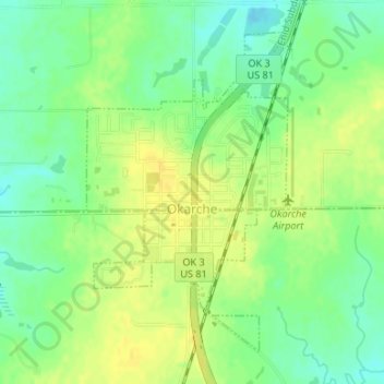
Nome: Mapa topográfico Okarche, altitude, relevo.
Local: Okarche, Kingfisher County, Oklahoma, United States (35.71578 -97.98617 35.73835 -97.96870)
Altitude média: 374 m
Altitude mínima: 361 m
Altitude máxima: 383 m
Outros mapas topográficos
Clique em um mapa para visualizar sua topografia, sua altitude e seu relevo.
Kingfisher
United States > Oklahoma > Kingfisher County
Kingfisher, Kingfisher County, Oklahoma, 73750, United States
Altitude média: 329 m
Omega
United States > Oklahoma > Kingfisher County
Omega, Kingfisher County, Oklahoma, 73764, United States
Altitude média: 367 m
Dover
United States > Oklahoma > Kingfisher County
Dover, Kingfisher County, Oklahoma, 73734, United States
Altitude média: 322 m
Cashion
United States > Oklahoma > Kingfisher County
Cashion, Kingfisher County, Oklahoma, 73016, United States
Altitude média: 339 m
Loyal
United States > Oklahoma > Kingfisher County
Loyal, Kingfisher County, Oklahoma, United States
Altitude média: 344 m