
Mapa topográfico Wilsford
Clique no mapa para exibir a altitude.
Sobre este mapa
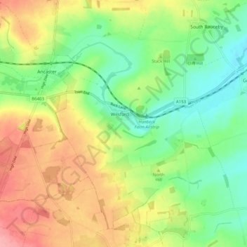
Nome: Mapa topográfico Wilsford, altitude, relevo.
Altitude média: 60 m
Altitude mínima: 17 m
Altitude máxima: 115 m
Outros mapas topográficos
Clique em um mapa para visualizar sua topografia, sua altitude e seu relevo.
Threekingham
United Kingdom > England > Lincolnshire > North Kesteven > Threekingham
Altitude média: 30 m
Helpringham
United Kingdom > England > Lincolnshire > North Kesteven > Helpringham
Altitude média: 8 m
Quarrington
United Kingdom > England > Lincolnshire > North Kesteven
According to the Köppen classification, the British Isles experience a maritime climate characterised by relatively cool summers and mild winters. Lincolnshire's position on the east of the Isles allows for a sunnier and warmer climate relative to the national average, and it is one of the driest counties in…
Altitude média: 21 m
Three Kings Deer
United Kingdom > England > Lincolnshire > North Kesteven > Threekingham
Altitude média: 24 m