
Faça uma doação
Mapa topográfico Taos Ski Valley
Clique no mapa para exibir a altitude.
Faça uma doação
Taos Ski Valley
Taos Ski Valley is a village and alpine ski resort in the southwestern United States, located in Taos County, New Mexico. The population was 69 at the 2010 census. Until March 19, 2008, it was one of four ski resorts in America to prohibit snowboarding. The Kachina lift, constructed in 2014, serves one of the highest elevations of any triple chair in North America, to a peak of 12,481 feet (3,804 m) above sea level.
Faça uma doação
Sobre este mapa
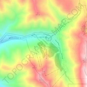
Nome: Mapa topográfico Taos Ski Valley, altitude, relevo.
Local: Taos Ski Valley, Taos County, New Mexico, United States (36.57279 -105.48367 36.61191 -105.42355)
Altitude média: 3.229 m
Altitude mínima: 2.716 m
Altitude máxima: 3.754 m
Faça uma doação
Outros mapas topográficos
Clique em um mapa para visualizar sua topografia, sua altitude e seu relevo.
Faça uma doação
Arroyo Seco
United States > New Mexico > Taos County
Arroyo Seco has a post office, with the ZIP code 87514. The 87514 ZIP Code Tabulation Area had a population of 1,310 at the 2000 census, with 996 housing units, a land area of 53.63 sq. miles, a water area of 0.05 sq. mile, and a population density of 24.43 people per sq. mile at Census 2000. Arroyo Seco's…
Altitude média: 2.338 m
Faça uma doação
Tres Piedras
United States > New Mexico > Taos County
Tres Piedras is located approximately 30 miles northwest of Taos, and west of the Rio Grande on U.S. Route 64. At approximately 8,000 feet (2,400 m) in altitude, it is located within the southern portion of the San Juan Range of the Rocky Mountains. Tres Piedras is on the western edge of a sagebrush plain,…
Altitude média: 2.476 m
Wheeler Peak
United States > New Mexico > Taos County
Wheeler Peak is the highest natural point in the U.S. state of New Mexico. It is located northeast of Taos and south of Red River in the northern part of the state, and just 2 miles (3.2 km) southeast of the ski slopes of Taos Ski Valley. It lies in the Sangre de Cristo Mountains, the southernmost subrange of…
Altitude média: 3.674 m
Faça uma doação