
Mapa topográfico Cadaclan
Clique no mapa para exibir a altitude.
Sobre este mapa
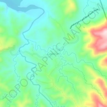
Nome: Mapa topográfico Cadaclan, altitude, relevo.
Altitude média: 308 m
Altitude mínima: 206 m
Altitude máxima: 559 m
Outros mapas topográficos
Clique em um mapa para visualizar sua topografia, sua altitude e seu relevo.
Pantabangan Dam
Philippines > Nueva Ecija > Pantabangan > Fatima
The dam is a 107 m (351 ft) tall and 1,615 m (5,299 ft) long embankment-type with 12,000,000 cu yd (9,174,658 m3) of homogeneous earth-fill and an impervious core. The crest of the dam is 12 m (39 ft) wide while the widest part of its base is 535 m (1,755 ft). The dam's crest sits at an elevation of 232 m (761…
Altitude média: 210 m