
Mapa topográfico Kaisersesch
Mapa interativo
Clique no mapa para exibir a altitude.
Sobre este mapa
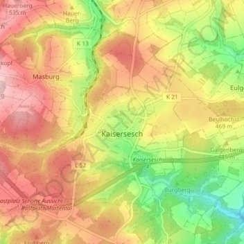
Nome: Mapa topográfico Kaisersesch, altitude, relevo.
Altitude média: 451 m
Altitude mínima: 334 m
Altitude máxima: 548 m
Outros mapas topográficos
Clique em um mapa para visualizar sua topografia, sua altitude e seu relevo.
Treis-Karden
Deutschland > Rheinland-Pfalz > Landkreis Cochem-Zell
Treis-Karden, Cochem, Landkreis Cochem-Zell, Rheinland-Pfalz, 56253, Deutschland
Altitude média: 241 m
Zell (Mosel)
Deutschland > Rheinland-Pfalz > Landkreis Cochem-Zell
Zell (Mosel), Landkreis Cochem-Zell, Rheinland-Pfalz, 56856, Deutschland
Altitude média: 287 m
Cochem
Deutschland > Rheinland-Pfalz > Landkreis Cochem-Zell
Cochem, Landkreis Cochem-Zell, Rheinland-Pfalz, Deutschland
Altitude média: 286 m
Beilstein
Deutschland > Rheinland-Pfalz > Landkreis Cochem-Zell > Beilstein
Beilstein, Cochem, Landkreis Cochem-Zell, Rheinland-Pfalz, Deutschland
Altitude média: 239 m