
Mapa topográfico Little Heath
Clique no mapa para exibir a altitude.
Sobre este mapa
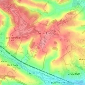
Nome: Mapa topográfico Little Heath, altitude, relevo.
Altitude média: 138 m
Altitude mínima: 86 m
Altitude máxima: 178 m
Outros mapas topográficos
Clique em um mapa para visualizar sua topografia, sua altitude e seu relevo.
Frithsden Beeches
United Kingdom > England > Hertfordshire > Dacorum > Potten End
Altitude média: 160 m