
Mapa topográfico Westchester
Mapa interativo
Clique no mapa para exibir a altitude.
Sobre este mapa
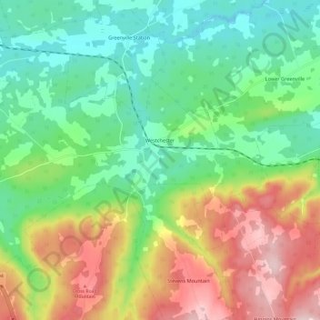
Nome: Mapa topográfico Westchester, altitude, relevo.
Altitude média: 157 m
Altitude mínima: 55 m
Altitude máxima: 331 m
Outros mapas topográficos
Clique em um mapa para visualizar sua topografia, sua altitude e seu relevo.
West Amherst
Canada > Nova Scotia > Municipality of the County of Cumberland
West Amherst, Municipality of the County of Cumberland, Cumberland County, Nova Scotia, B4H 3Y4, Canada
Altitude média: 13 m
Mapleton
Canada > Nova Scotia > Municipality of the County of Cumberland
Mapleton, Municipality of the County of Cumberland, Cumberland County, Nova Scotia, B0M 1W0, Canada
Altitude média: 102 m
Beckwith
Canada > Nova Scotia > Municipality of the County of Cumberland
Beckwith, Municipality of the County of Cumberland, Cumberland County, Nova Scotia, Canada
Altitude média: 44 m
Northport
Canada > Nova Scotia > Municipality of the County of Cumberland
Northport, Municipality of the County of Cumberland, Cumberland County, Nova Scotia, B0L 1E0, Canada
Altitude média: 12 m
Maccan
Canada > Nova Scotia > Municipality of the County of Cumberland
Maccan, Municipality of the County of Cumberland, Cumberland County, Nova Scotia, B0L 1B0, Canada
Altitude média: 45 m
Parrsboro
Canada > Nova Scotia > Municipality of the County of Cumberland
Parrsboro, Municipality of the County of Cumberland, Cumberland County, Nova Scotia, B0M 1S0, Canada
Altitude média: 25 m
Gulf Shore
Canada > Nova Scotia > Municipality of the County of Cumberland > Gulf Shore
Gulf Shore, Municipality of the County of Cumberland, Cumberland County, Nova Scotia, B0K 1L0, Canada
Altitude média: 11 m