
Faça uma doação
Mapa topográfico Whetstone
Clique no mapa para exibir a altitude.
Faça uma doação
Sobre este mapa
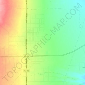
Nome: Mapa topográfico Whetstone, altitude, relevo.
Local: Whetstone, Cochise County, Arizona, United States (31.67644 -110.38287 31.73135 -110.30153)
Altitude média: 1.324 m
Altitude mínima: 1.278 m
Altitude máxima: 1.394 m
Faça uma doação
Outros mapas topográficos
Clique em um mapa para visualizar sua topografia, sua altitude e seu relevo.
Kartchner Caverns State Park
United States > Arizona > Cochise County > Benson
Altitude média: 1.432 m
Faça uma doação
Faça uma doação
Bakerville
United States > Arizona > Cochise County > Bisbee > Warren
Bakerville is a populated place situated within the city of Bisbee in Cochise County, Arizona, United States. It has an estimated elevation of 5,039 feet (1,536 m) above sea level.
Altitude média: 1.579 m
Faça uma doação
Ramsey
United States > Arizona > Cochise County > Sierra Vista
In the Köppen climate classification system, Sierra Vista Southeast falls within the typical cold semi-arid climate (BSk) of mid-altitude Arizona. Fall and spring, like most other parts of Arizona, are very dry. Winters are cool to cold with frosts which can occasionally be hard freezes; frost can be expected…
Altitude média: 1.932 m
Faça uma doação
Bledsoe
United States > Arizona > Cochise County > Sierra Vista > Bledsoe
Bledsoe is a populated place situated in Cochise County, Arizona, United States. It has an estimated elevation of 5,545 feet (1,690 m) above sea level.
Altitude média: 1.858 m
Apache
United States > Arizona > Cochise County > Apache
Apache is a ghost town in Cochise County, Arizona, United States. It has an estimated elevation of 4,383 feet (1,336 m) above sea level.
Altitude média: 1.340 m
Tombstone
United States > Arizona > Cochise County > Tombstone > Tombstone
The Tombstone District located at 31°42′57″N 110°3′53″W / 31.71583°N 110.06472°W / 31.71583; -110.06472 (31.715940, −110.064827) sits atop a mesa (elevation 4,539 feet ) in the San Pedro River valley between the Huachuca Mountains and Whetstone Mountains to the west, and the Mules and…
Altitude média: 1.373 m
Faça uma doação