
Mapa topográfico Tláhuac
Mapa interativo
Clique no mapa para exibir a altitude.
Sobre este mapa
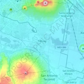
Nome: Mapa topográfico Tláhuac, altitude, relevo.
Local: Tláhuac, Mexico City, Mexico (19.21057 -99.06897 19.32713 -98.94030)
Altitude média: 2.288 m
Altitude mínima: 2.223 m
Altitude máxima: 2.740 m
The borough of Tláhuac is located in the southeastern part of the Mexico City, about 60 km from the historic center of Mexico City . It is bordered by the boroughs of Iztapalapa, Milpa Alta and Xochimilco as well as the municipality of Valle de Chalco Solidaridad in the State of Mexico . The borough extends over 89.5.km2 of territory, accounting for 5.75% of the Mexico City. The borough is part of the Valley of Mexico, in the Trans-Mexican Volcanic Belt that extends across central Mexico. The borough expands over much of the former Lake Chalco and Lake Xochimilco where the two connected, which were drained over the centuries since the Spanish conquest. The territory is classified into three zones, flat lakebed, transitional areas and hills with accumulated volcanic materials. The main elevations include the Guadalupe Volcano, the Xaltepec Volcano, Tecuautzi, Tetecón, the Sierra de Santa Catarina and Teuhtli Volcano. The Sierra de Santa Catarina is a small volcanic belt which has elevations of up to 2,800 meters above sea level. It serves as an important aquifer recharge area as well as a barrier to urban sprawl from Iztapalapa on the other side. On the south end is the Tehuitli Volcanco with an altitude of 2,700 meters above sea level.
Outros mapas topográficos
Clique em um mapa para visualizar sua topografia, sua altitude e seu relevo.
Parque España
Parque España, Condesa, Cuauhtémoc, Mexico City, 06140, Mexico
Altitude média: 2.242 m
Island of the Dead Dolls
Island of the Dead Dolls, Xochimilco, Mexico City, 16043, Mexico
Altitude média: 2.235 m
Bosque de Chapultepec
Bosque de Chapultepec, Mexico City, 11590, Mexico
Altitude média: 2.296 m