
Mapa topográfico Hainhofen
Mapa interativo
Clique no mapa para exibir a altitude.
Sobre este mapa
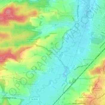
Nome: Mapa topográfico Hainhofen, altitude, relevo.
Local: Hainhofen, Neusäß, Landkreis Augsburg, Bayern, Deutschland (48.37914 10.75748 48.39486 10.80822)
Altitude média: 486 m
Altitude mínima: 454 m
Altitude máxima: 544 m
Outros mapas topográficos
Clique em um mapa para visualizar sua topografia, sua altitude e seu relevo.
Täfertingen
Deutschland > Bayern > Landkreis Augsburg > Neusäß
Täfertingen, Neusäß, Landkreis Augsburg, Bayern, Deutschland
Altitude média: 473 m
Steppach
Deutschland > Bayern > Landkreis Augsburg > Neusäß > Steppach
Steppach, Neusäß, Landkreis Augsburg, Bayern, Deutschland
Altitude média: 501 m