
Mapa topográfico Stiefenhofen
Mapa interativo
Clique no mapa para exibir a altitude.
Sobre este mapa
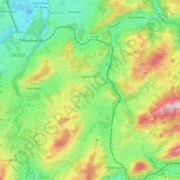
Nome: Mapa topográfico Stiefenhofen, altitude, relevo.
Altitude média: 819 m
Altitude mínima: 640 m
Altitude máxima: 1.105 m
Outros mapas topográficos
Clique em um mapa para visualizar sua topografia, sua altitude e seu relevo.
Scheidegg
Deutschland > Bayern > Landkreis Lindau
Scheidegg, Weiler-Simmerberg, Landkreis Lindau, Bayern, 88175, Deutschland
Altitude média: 748 m
Egghalden
Deutschland > Bayern > Landkreis Lindau > Zeisertsweiler
Egghalden, Zeisertsweiler, Sigmarszell, Sigmarszell (VGem), Landkreis Lindau, Bayern, 88138, Deutschland
Altitude média: 481 m
Rickenbach
Deutschland > Bayern > Landkreis Lindau > Lindau (Bodensee)
Rickenbach, Lindau (Bodensee), Landkreis Lindau, Bayern, 88131, Deutschland
Altitude média: 428 m