
Faça uma doação
Mapa topográfico Tambra
Clique no mapa para exibir a altitude.
Faça uma doação
Sobre este mapa
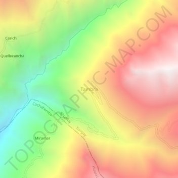
Nome: Mapa topográfico Tambra, altitude, relevo.
Local: Tambra, Shupluy, Province of Yungay, Ancash, Peru (-9.42051 -77.86380 -9.38051 -77.82380)
Altitude média: 3.704 m
Altitude mínima: 2.728 m
Altitude máxima: 4.611 m
Faça uma doação
Outros mapas topográficos
Clique em um mapa para visualizar sua topografia, sua altitude e seu relevo.
Huascarán National Park
Huascarán National Park protects the Cordillera Blanca, which is the world's highest tropical mountain range. Located in the central Peruvian Andes, the park's 340,000 hectares (840,000 acres) cover an elevational range from around 2,500 meters (8,200 ft) to the several snow-capped peaks above 6,000 meters…
Altitude média: 3.681 m
Faça uma doação
Province of Yungay
The Cordillera Blanca and the Cordillera Negra traverse the province. Waskaran, the highest elevation of Peru, lies on the border with the province of Carhuaz. Chakrarahu, Chopicalqui, Tullparahu and Yanarahu (Ruriqucha) belong to the highest peaks of the province. Other mountains are listed below.
Altitude média: 3.808 m
Mato
The district is located in the west-central part of the province at an elevation of 2,239m in the black mountains (Spanish: Cordillera Negra), neighboring district is the Caraz district in which the provinces capital Caraz is located, 12 km from the village of Villa Sucre. The regions capital Huaraz is located…
Altitude média: 3.455 m
Faça uma doação
Mancos
Mancos, is the main district of the Province of Yungay. It is located in the central part of the Callejon de Huaylas, in the right margin of the Rio Santa, snow at the foot of the colossus that is Mount Huascaran dominant eastern side and whose melting born Mancos River crossing from east to west to flow into…
Altitude média: 3.016 m
Faça uma doação
Faça uma doação
Santo Toribio
The district is located in the north-western part of the province at an elevation of 2,860m.
Altitude média: 3.095 m
Faça uma doação
Laguna Palcacocha
Peru > Ancash > Independencia
Palcacocha is located at 9°23′49″S 77°22′47″W / 9.39694°S 77.37972°W / -9.39694; -77.37972 in the Ancash Region in Cordillera Blanca at an elevation of 4,566 m, just below the summits of Palcaraju (6,274 m) and Pucaranra (6,156 m). The lake is one of several lakes supplying the town Huaraz…
Altitude média: 4.857 m
Faça uma doação
Province of Yungay
The Cordillera Blanca and the Cordillera Negra traverse the province. Waskaran, the highest elevation of Peru, lies on the border with the province of Carhuaz. Chakrarahu, Chopicalqui, Tullparahu and Yanarahu (Ruriqucha) belong to the highest peaks of the province. Other mountains are listed below.
Altitude média: 3.808 m
Faça uma doação
Faça uma doação
Huascarán National Park
Huascarán National Park protects the Cordillera Blanca, which is the world's highest tropical mountain range. Located in the central Peruvian Andes, the park's 340,000 hectares (840,000 acres) cover an elevational range from around 2,500 meters (8,200 ft) to the several snow-capped peaks above 6,000 meters…
Altitude média: 3.681 m
Faça uma doação
Faça uma doação
Chavin Archaeological Site
Peru > Ancash > Chavín de Huantar > Chavin de Huantar > Cochas
Chavín de Huántar is an archaeological site in Peru, containing ruins and artifacts constructed as early as 1200 BC, and occupied until around 400–500 BC by the Chavín, a major pre-Inca culture. The site is located in the Ancash Region, 434 kilometers (270 mi) north of Lima, at an elevation of 3,180…
Altitude média: 3.407 m
Faça uma doação
Faça uma doação
Province of Carhuaz
The Cordillera Blanca traverses the province. Waskaran, its highest elevation, lies on the border to the Yungay Province. Pallqarahu, Pukaranra, Qupa, Tuqllarahu, Wallqan and Yanarahu belong to the highest peaks of the province. Other mountains are listed below:[2]
Altitude média: 4.038 m
Faça uma doação
Faça uma doação