Geolocalizar

Mapa topográfico Buntingford

Mapa interativo

Clique no mapa para exibir a altitude.

Sobre este mapa

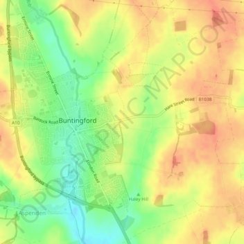
Nome: Mapa topográfico Buntingford, altitude, relevo.

Local: Buntingford, East Hertfordshire, Hertfordshire, England, United Kingdom (51.93250 -0.03054 51.96049 0.01634)

Altitude média: 110 m

Altitude mínima: 81 m

Altitude máxima: 129 m

Outros mapas topográficos

Clique em um mapa para visualizar sua topografia, sua altitude e seu relevo.

Pelham Gate

United Kingdom > England > Hertfordshire > East Hertfordshire

Pelham Gate, Brent Pelham, East Hertfordshire, Hertfordshire, England, SG9 0HL, United Kingdom

Altitude média: 113 m

Much Hadham

United Kingdom > England > Hertfordshire > East Hertfordshire

Much Hadham, East Hertfordshire, Hertfordshire, England, United Kingdom

Altitude média: 80 m

Bishops Stortford Elsan Point

United Kingdom > England > Hertfordshire > East Hertfordshire

Bishops Stortford Elsan Point, East Hertfordshire, Hertfordshire, East of England, England, CM23 3BL, United Kingdom

Altitude média: 78 m

Thorley

United Kingdom > England > Hertfordshire > East Hertfordshire > Thorley

Thorley, East Hertfordshire, Hertfordshire, East of England, England, United Kingdom

Altitude média: 82 m