
Obrigado por apoiar este site ❤️
Faça uma doação
Faça uma doação
Mapa topográfico Gokyo
Clique no mapa para exibir a altitude.
Obrigado por apoiar este site ❤️
Faça uma doação
Faça uma doação
Gokyo
Located at an elevation of 4,750 m (15,584 ft), the village is one of the highest settlements in Nepal and in the world. Almost all the buildings are guest houses for trekkers. The people who live in the village leave during the winter and move to other (lower) villages, or Kathmandu.
Obrigado por apoiar este site ❤️
Faça uma doação
Faça uma doação
Sobre este mapa
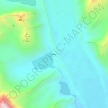
Nome: Mapa topográfico Gokyo, altitude, relevo.
Altitude média: 4.919 m
Altitude mínima: 4.676 m
Altitude máxima: 5.926 m
Obrigado por apoiar este site ❤️
Faça uma doação
Faça uma doação
Outros mapas topográficos
Clique em um mapa para visualizar sua topografia, sua altitude e seu relevo.