
Faça uma doação
Mapa topográfico Ashton-under-Lyne
Clique no mapa para exibir a altitude.
Faça uma doação
Ashton-under-Lyne
At 53°29′38″N 2°6′11″W / 53.49389°N 2.10306°W / 53.49389; -2.10306 (53.4941°, −2.1032°), and 160 miles (257 km) north-northwest of London, Ashton-under-Lyne stands on the north bank of the River Tame, about 35 feet (11 m) above the river. Described in Samuel Lewis's A Topographical Dictionary of England (1848) as situated "on a gentle declivity", Ashton-under-Lyne lies on undulating ground by the Pennines, reaching a maximum elevation of about 1,000 feet (305 m) above sea level. Generally the bedrock of the west of the town consists of coal measures, which were exploited by the coal mining industry, while the east is mainly millstone grit. Overlying the bedrock are deposits of glacial sand and gravel, clay, and some alluvial deposits. Ashton Moss, a peat bog, lies to the west of the town and was originally much larger.
Faça uma doação
Sobre este mapa
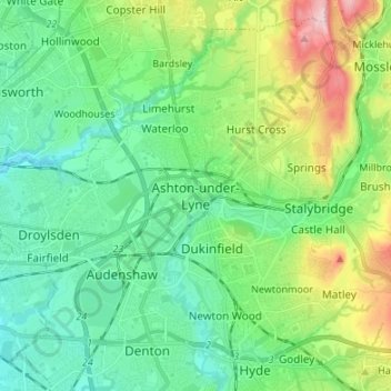
Nome: Mapa topográfico Ashton-under-Lyne, altitude, relevo.
Altitude média: 129 m
Altitude mínima: 63 m
Altitude máxima: 306 m
Faça uma doação
Outros mapas topográficos
Clique em um mapa para visualizar sua topografia, sua altitude e seu relevo.