
Faça uma doação
Mapa topográfico Osgathorpe
Clique no mapa para exibir a altitude.
Faça uma doação
Sobre este mapa
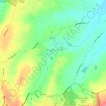
Nome: Mapa topográfico Osgathorpe, altitude, relevo.
Altitude média: 96 m
Altitude mínima: 67 m
Altitude máxima: 137 m
Faça uma doação
Outros mapas topográficos
Clique em um mapa para visualizar sua topografia, sua altitude e seu relevo.
Kelham Bridge Nature Reserve
United Kingdom > England > Leicestershire > North West Leicestershire > Ravenstone
Altitude média: 139 m
Faça uma doação
Isley Walton
United Kingdom > England > Leicestershire > North West Leicestershire
Altitude média: 76 m
Thringstone
United Kingdom > England > Leicestershire > North West Leicestershire
Altitude média: 126 m
Lount Wood
United Kingdom > England > Leicestershire > North West Leicestershire > Lount
Altitude média: 131 m
Faça uma doação
Breedon on the Hill
United Kingdom > England > Leicestershire > North West Leicestershire
Altitude média: 84 m
Ravenstone
United Kingdom > England > Leicestershire > North West Leicestershire
Altitude média: 143 m
Nailstone Colliery Railway
United Kingdom > England > Leicestershire > North West Leicestershire > Ibstock
Altitude média: 155 m
Long Whatton
United Kingdom > England > Leicestershire > North West Leicestershire
Altitude média: 63 m
Faça uma doação
Timberwood Hill
United Kingdom > England > Leicestershire > North West Leicestershire
Altitude média: 192 m
Breedon Cloud Wood
United Kingdom > England > Leicestershire > North West Leicestershire > Breedon on the Hill
Altitude média: 90 m
Swannymote Rock
United Kingdom > England > Leicestershire > North West Leicestershire > Coalville
Altitude média: 139 m
Willesley Woods
United Kingdom > England > Leicestershire > North West Leicestershire > Ashby-de-la-Zouch > Willesley
Altitude média: 108 m
Faça uma doação
Hugglescote
United Kingdom > England > Leicestershire > North West Leicestershire
Altitude média: 154 m
Bardon Hill
United Kingdom > England > Leicestershire > North West Leicestershire
Altitude média: 199 m
Ashby de la Zouch Canal
United Kingdom > England > Leicestershire > North West Leicestershire > Moira
Altitude média: 100 m
Faça uma doação
Albert Village
United Kingdom > England > Leicestershire > North West Leicestershire
Altitude média: 113 m
Oaks in Charnwood
United Kingdom > England > Leicestershire > North West Leicestershire
Altitude média: 155 m
Faça uma doação
Donington Le Heath
United Kingdom > England > Leicestershire > North West Leicestershire
Altitude média: 148 m
Shellbrook
United Kingdom > England > Leicestershire > North West Leicestershire > Ashby-de-la-Zouch > Blackfordby
Altitude média: 128 m
Cademan Wood
United Kingdom > England > Leicestershire > North West Leicestershire > Whitwick
Altitude média: 138 m
Faça uma doação
Ashby de la Zouch Canal
United Kingdom > England > Leicestershire > North West Leicestershire > Oakthorpe
Altitude média: 97 m
Peggs Green
United Kingdom > England > Leicestershire > North West Leicestershire > Peggs Green
Altitude média: 121 m
Farmtown
United Kingdom > England > Leicestershire > North West Leicestershire > Coleorton
Altitude média: 141 m
Faça uma doação
Sence Valley Country Park
United Kingdom > England > Leicestershire > North West Leicestershire > Coalville > Heather
Altitude média: 131 m
Faça uma doação
Isley Walton
United Kingdom > England > Leicestershire > North West Leicestershire
Altitude média: 76 m