
Mapa topográfico Isalo National Park
Mapa interativo
Clique no mapa para exibir a altitude.
Isalo National Park
Isalo National Park is a National Park in the Ihorombe Region of Madagascar, in the southwestern corner of the Province of Fianarantsoa. The closest town is Ranohira, and the closest cities are Toliara and Ihosy. It is a sandstone landscape that has been dissected by wind and water erosion into rocky outcrops, plateaus, extensive plains and up to 200 m (660 ft) deep canyons. There are permanent rivers and streams as well as many seasonal watercourses. Elevation varies between 510 and 1,268 m (1,673 and 4,160 ft).
Sobre este mapa
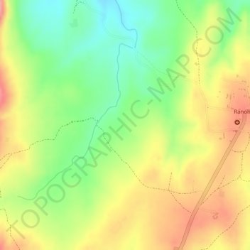
Nome: Mapa topográfico Isalo National Park, altitude, relevo.
Altitude média: 803 m
Altitude mínima: 746 m
Altitude máxima: 855 m