
Mapa topográfico Traverse City
Mapa interativo
Clique no mapa para exibir a altitude.
Sobre este mapa
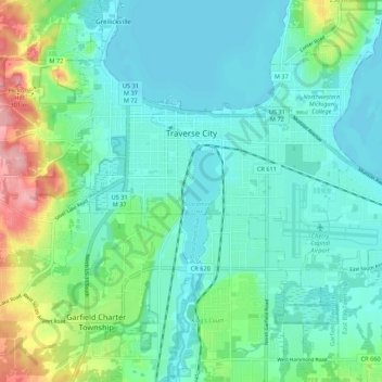
Nome: Mapa topográfico Traverse City, altitude, relevo.
Altitude média: 204 m
Altitude mínima: 174 m
Altitude máxima: 307 m
The locale and topography is conducive for road bicycling, aided by the TART trail system. A map with routes, different trips, advice and local knowledge is available. Lake Michigan presents a location for sailing, fishing, and kayaking.
Outros mapas topográficos
Clique em um mapa para visualizar sua topografia, sua altitude e seu relevo.
Grand Traverse Bay
United States > Michigan > Grand Traverse County
Grand Traverse Bay, Grand Traverse County, Michigan, 49682, United States
Altitude média: 201 m
Interlochen
United States > Michigan > Grand Traverse County
Interlochen, Green Lake Township, Grand Traverse County, Michigan, 49643, United States
Altitude média: 257 m
Williamsburg
United States > Michigan > Grand Traverse County
Williamsburg, Whitewater Township, Grand Traverse County, Michigan, 49690, United States
Altitude média: 228 m
East Bay Township
United States > Michigan > Grand Traverse County
East Bay Township, Grand Traverse County, Michigan, United States
Altitude média: 252 m