
Mapa topográfico Westmoreland
Mapa interativo
Clique no mapa para exibir a altitude.
Sobre este mapa
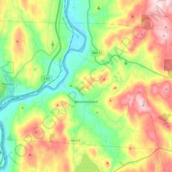
Nome: Mapa topográfico Westmoreland, altitude, relevo.
Altitude média: 228 m
Altitude mínima: 62 m
Altitude máxima: 465 m
According to the United States Census Bureau, the town has a total area of 36.8 square miles (95.4 km2), of which 35.8 square miles (92.7 km2) is land and 1.0 square mile (2.7 km2), or 2.80%, is water. Westmoreland is bounded on the west by the Connecticut River, which is the state border with Vermont. Hyland Hill, elevation 1,510 feet (460 m) and the highest point in town, is on the eastern border and although it is now private land, it is a local hiking and hunting destination.
Outros mapas topográficos
Clique em um mapa para visualizar sua topografia, sua altitude e seu relevo.
Stoddard
United States > New Hampshire > Cheshire County
Stoddard, Cheshire County, New Hampshire, United States
Altitude média: 451 m
Chesterfield
United States > New Hampshire > Cheshire County
Chesterfield, Cheshire County, New Hampshire, United States
Altitude média: 229 m
Harrisville
United States > New Hampshire > Cheshire County
Harrisville, Cheshire County, New Hampshire, 03450, United States
Altitude média: 422 m
Gilboa Mountain
United States > New Hampshire > Cheshire County > Westmoreland
Gilboa Mountain, Westmoreland, Cheshire County, New Hampshire, 03467, United States
Altitude média: 331 m
Alstead
United States > New Hampshire > Cheshire County
Alstead, Cheshire County, New Hampshire, United States
Altitude média: 289 m
West Chesterfield
United States > New Hampshire > Cheshire County > Chesterfield
West Chesterfield, Chesterfield, Cheshire County, New Hampshire, 03466, United States
Altitude média: 168 m
Rindge
United States > New Hampshire > Cheshire County
Rindge, Cheshire County, New Hampshire, United States
Altitude média: 343 m
Marlborough
United States > New Hampshire > Cheshire County
Marlborough, Cheshire County, New Hampshire, 03455, United States
Altitude média: 299 m
Winchester
United States > New Hampshire > Cheshire County > Winchester
Winchester, Cheshire County, New Hampshire, United States
Altitude média: 167 m
Pisgah State Park
United States > New Hampshire > Cheshire County > Winchester
Pisgah State Park, Winchester, Cheshire County, New Hampshire, United States
Altitude média: 250 m
Keene
United States > New Hampshire > Cheshire County
Keene, Cheshire County, New Hampshire, United States
Altitude média: 263 m
Harper Acres
United States > New Hampshire > Cheshire County > Keene
Harper Acres, Keene, Cheshire County, New Hampshire, 03431, United States
Altitude média: 156 m
Fitzwilliam
United States > New Hampshire > Cheshire County
Fitzwilliam, Cheshire County, New Hampshire, 03447, United States
Altitude média: 345 m
Jaffrey
United States > New Hampshire > Cheshire County
Jaffrey, Cheshire County, New Hampshire, 03452, United States
Altitude média: 351 m
Monte Rosa
United States > New Hampshire > Cheshire County > Jaffrey
Monte Rosa, Jaffrey, Cheshire County, New Hampshire, United States
Altitude média: 634 m