
Obrigado por apoiar este site ❤️
Faça uma doação
Faça uma doação
Mapa topográfico Vermont Heights
Clique no mapa para exibir a altitude.
Obrigado por apoiar este site ❤️
Faça uma doação
Faça uma doação
Vermont Heights
Vermont Heights is located at 29°48′36″N 81°23′50″W / 29.81°N 81.3972°W / 29.81; -81.3972 (29.81, -81.3972) Elevation of 46 Feet. Vermont Heights is the location of the Coquina Crossing Mobile Home Park and St. Augustine Community School of Performing Arts, both of which give their addresses as being in Elkton to the southwest.
Obrigado por apoiar este site ❤️
Faça uma doação
Faça uma doação
Sobre este mapa
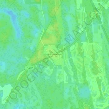
Nome: Mapa topográfico Vermont Heights, altitude, relevo.
Altitude média: 13 m
Altitude mínima: 6 m
Altitude máxima: 18 m
Obrigado por apoiar este site ❤️
Faça uma doação
Faça uma doação
Outros mapas topográficos
Clique em um mapa para visualizar sua topografia, sua altitude e seu relevo.
Castillo de San Marcos
United States > Florida > Saint Johns County > Saint Augustine
Altitude média: 2 m
Julington Creek Plantation Park
United States > Florida > Saint Johns County > Fruit Cove
Altitude média: 7 m
Obrigado por apoiar este site ❤️
Faça uma doação
Faça uma doação