
Faça uma doação
Mapa topográfico Scarborough
Clique no mapa para exibir a altitude.
Faça uma doação
Scarborough
Topographically, the district is dominated by two watersheds, Highland Creek and the Rouge River. Highland Creek lies almost entirely within Scarborough and occupies approximately 70% of its total area. It occupies the western half of Scarborough, while the Rouge River flows through the eastern portion. Both of these rivers flow into Lake Ontario. Due to the location of the Lakeshore CN railway right-of-way, both river deltas are constricted to narrow channels where they flow into the lake.
Faça uma doação
Sobre este mapa
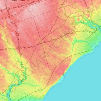
Nome: Mapa topográfico Scarborough, altitude, relevo.
Local: Scarborough, Toronto, Golden Horseshoe, Ontario, Canada (43.66972 -79.34134 43.85544 -79.11322)
Altitude média: 138 m
Altitude mínima: 71 m
Altitude máxima: 209 m
Faça uma doação
Outros mapas topográficos
Clique em um mapa para visualizar sua topografia, sua altitude e seu relevo.
Toronto
Despite its deep ravines, Toronto is not remarkably hilly, but its elevation does increase steadily away from the lake. Elevation differences range from 76.5 metres (251 ft) above sea level at the Lake Ontario shore to 209 m (686 ft) ASL near the York University grounds in the city's north end at the…
Altitude média: 113 m
Faça uma doação
Faça uma doação
Faça uma doação
Faça uma doação
Faça uma doação
Faça uma doação
Faça uma doação
Faça uma doação
Faça uma doação
Faça uma doação
Faça uma doação
Faça uma doação