
Mapa topográfico Kollam
Mapa interativo
Clique no mapa para exibir a altitude.
Sobre este mapa
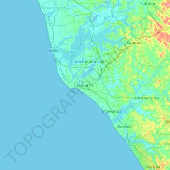
Nome: Mapa topográfico Kollam, altitude, relevo.
Local: Kollam, Kollam District, Kerala, 691001, India (8.72795 76.43550 9.04795 76.75550)
Altitude média: 12 m
Altitude mínima: -2 m
Altitude máxima: 122 m
Cosmas Indicopleustes, a Greek Nestorian sailor, in his book the Christian Topography who visited the Malabar Coast in 550, mentions an enclave of Christian believers in Male (Malabar Coast). He writes, "In the island of Tabropane (Ceylon), there is a church of Christians, and clerics and faithful. Likewise at Male, where the pepper grows, and in the farming community of Kalliana (Kalliankal at Nillackal) there is also a bishop consecrated in Persia in accordance with the Nicea Sunnahadose of 325 AD." The Nestorian Patriarch Jesujabus, who died in 660 AD, mentions Kollam in his letter to Simon, Metropolitan of Persia.
Outros mapas topográficos
Clique em um mapa para visualizar sua topografia, sua altitude e seu relevo.
Kizhakkekallada
Kizhakkekallada, Kollam, Kollam District, Kerala, 691502, India
Altitude média: 10 m
Sakthikulangara
Sakthikulangara, Kollam, Kerala, 691581, India
Altitude média: 4 m
Uliyakovil
India > Kerala > Kollam > Kollam
Uliyakovil, Kollam, Kerala, 691001, India
Altitude média: 10 m