
Obrigado por apoiar este site ❤️
Faça uma doação
Faça uma doação
Mapa topográfico Mount Kalatungan
Clique no mapa para exibir a altitude.
Obrigado por apoiar este site ❤️
Faça uma doação
Faça uma doação
Mount Kalatungan
Mount Kalatungan is the fifth highest mountain in the country with an elevation of 2,880 m (9,450 ft) asl. It is one of the several high elevation peaks in the Kalatungan Mountain Range in Bukidnon on the island of Mindanao, the second largest island in the Philippines.
Obrigado por apoiar este site ❤️
Faça uma doação
Faça uma doação
Sobre este mapa
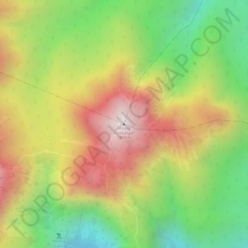
Nome: Mapa topográfico Mount Kalatungan, altitude, relevo.
Altitude média: 2.481 m
Altitude mínima: 2.079 m
Altitude máxima: 2.864 m
Obrigado por apoiar este site ❤️
Faça uma doação
Faça uma doação
Outros mapas topográficos
Clique em um mapa para visualizar sua topografia, sua altitude e seu relevo.