
Mapa topográfico Chorin
Mapa interativo
Clique no mapa para exibir a altitude.
Sobre este mapa
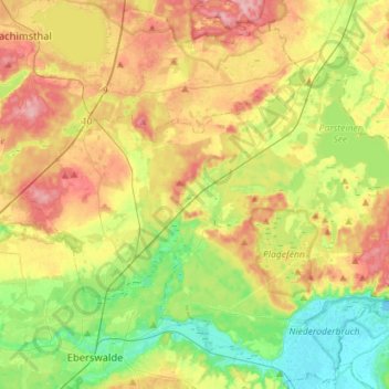
Nome: Mapa topográfico Chorin, altitude, relevo.
Local: Chorin, Britz-Chorin-Oderberg, Barnim, Brandenburg, Germany (52.84611 13.74332 52.96747 14.02713)
Altitude média: 55 m
Altitude mínima: -2 m
Altitude máxima: 125 m
Outros mapas topográficos
Clique em um mapa para visualizar sua topografia, sua altitude e seu relevo.
Ahrensfelde
Germany > Brandenburg > Barnim
Ahrensfelde, Barnim, Brandenburg, 16356, Germany
Altitude média: 67 m
Eberswalde
Germany > Brandenburg > Barnim
Eberswalde, Barnim, Brandenburg, Germany
Altitude média: 53 m
Bernau bei Berlin
Germany > Brandenburg > Barnim > Bernau > Bernau bei Berlin
Bernau bei Berlin, Bernau, Barnim, Brandenburg, 16321, Germany
Altitude média: 77 m
Biesenthal
Germany > Brandenburg > Barnim > Biesenthal-Barnim
Biesenthal, Biesenthal-Barnim, Barnim, Brandenburg, 16359, Germany
Altitude média: 59 m