
Mapa topográfico Theodore Roosevelt National Park
Mapa interativo
Clique no mapa para exibir a altitude.
Sobre este mapa
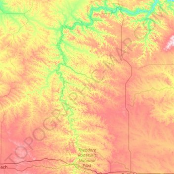
Nome: Mapa topográfico Theodore Roosevelt National Park, altitude, relevo.
Altitude média: 756 m
Altitude mínima: 573 m
Altitude máxima: 1.000 m
The wilderness protects from development the wildest sections of the National Park, an area described as badlands where erosional forces have carved steep cliffs into the relatively flat prairie. Bison, pronghorn, elk, mule deer and coyote are all found here, along with hundreds of species of birds such as the bald eagle, falcon and hawk. The wilderness is separated into two sections along with the park, a north and a south unit, by a distance of 70 miles (110 km). The Little Missouri River is on the south side of both units and is credited for being the primary erosional source which created the badlands topography.
Outros mapas topográficos
Clique em um mapa para visualizar sua topografia, sua altitude e seu relevo.
Medora
United States > North Dakota > Billings County
Medora, Billings County, North Dakota, 58645, United States
Altitude média: 720 m