
Mapa topográfico Dechmont
Clique no mapa para exibir a altitude.
Sobre este mapa
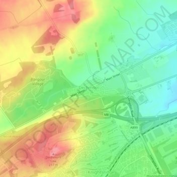
Nome: Mapa topográfico Dechmont, altitude, relevo.
Local: Dechmont, West Lothian, Scotland, United Kingdom (55.91916 -3.54538 55.92296 -3.52878)
Altitude média: 155 m
Altitude mínima: 111 m
Altitude máxima: 207 m
Outros mapas topográficos
Clique em um mapa para visualizar sua topografia, sua altitude e seu relevo.
Bathgate
United Kingdom > Scotland > West Lothian
In the 1846 book A Topographical Dictionary of Scotland, Samuel Lewis writes.
Altitude média: 167 m
Armadale
United Kingdom > Scotland > West Lothian
Aside from the presence of the old castle, Armadale was little more than a rural farm community for most of its history, as part of a larger rural estate named Barbauchlaw (a corruption of 'Boar Baughlee'). However, this situation changed with the coming of the new turnpike road between Edinburgh and Glasgow…
Altitude média: 166 m
Bathgate
United Kingdom > Scotland > West Lothian
In the 1846 book A Topographical Dictionary of Scotland, Samuel Lewis writes.
Altitude média: 167 m