
Faça uma doação
Mapa topográfico Denmark
Clique no mapa para exibir a altitude.
Faça uma doação
Sobre este mapa
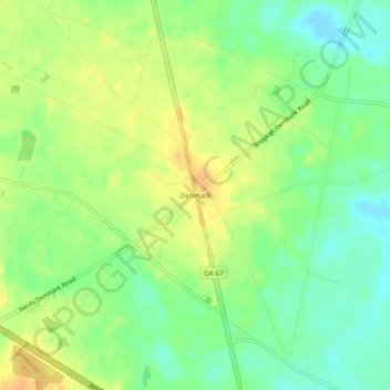
Nome: Mapa topográfico Denmark, altitude, relevo.
Local: Denmark, Bulloch County, Georgia, United States (32.26463 -81.74400 32.30463 -81.70400)
Altitude média: 45 m
Altitude mínima: 29 m
Altitude máxima: 60 m
Faça uma doação
Outros mapas topográficos
Clique em um mapa para visualizar sua topografia, sua altitude e seu relevo.
Statesboro
United States > Georgia > Bulloch County
According to the United States Census Bureau, the city has a total area of 13.9 square miles (35.9 km2), of which 13.5 square miles (35.0 km2) is land and 0.35 square miles (0.9 km2), or 2.60%, is water. The city is in the coastal plain region, or Low Country, of Georgia, so it is mainly flat with a few small…
Altitude média: 64 m
Faça uma doação
Statesboro
United States > Georgia > Bulloch County
According to the United States Census Bureau, the city has a total area of 13.9 square miles (35.9 km2), of which 13.5 square miles (35.0 km2) is land and 0.35 square miles (0.9 km2), or 2.60%, is water. The city is in the coastal plain region, or Low Country, of Georgia, so it is mainly flat with a few small…
Altitude média: 64 m