

Mapa topográfico Gangtok
Clique no mapa para exibir a altitude.
Gangtok
Gangtok (Nepali: [gantok] gāntok, Sikkimese: [ɡaŋt̪ʰòk]) is the capital and the most populous city of the Indian state of Sikkim. The seat of eponymous district, Gangtok is in the eastern Himalayan range, at an elevation of 1,650 m (5,410 ft). The city's population of 100,000 consists of the three Sikkimese ethnicities the Bhutias, Lepchas, Nepalis and also plainsmen from other states of India have settled here. Within the higher peaks of the Himalayas and with a year-round mild temperate climate, Gangtok is at the centre of Sikkim's tourism industry.
Sobre este mapa
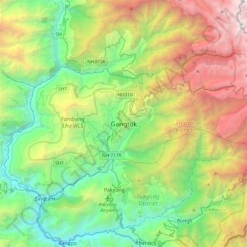
Nome: Mapa topográfico Gangtok, altitude, relevo.
Local: Gangtok, Gangtok subdivision, Gangtok, Sikkim, 737101, India (27.16905 88.45227 27.48905 88.77227)
Altitude média: 1.911 m
Altitude mínima: 283 m
Altitude máxima: 5.193 m
Outros mapas topográficos
Clique em um mapa para visualizar sua topografia, sua altitude e seu relevo.
