
Faça uma doação
Mapa topográfico Little Mell Fell
Clique no mapa para exibir a altitude.
Faça uma doação
Sobre este mapa
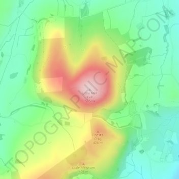
Nome: Mapa topográfico Little Mell Fell, altitude, relevo.
Altitude média: 314 m
Altitude mínima: 198 m
Altitude máxima: 505 m
Faça uma doação
Outros mapas topográficos
Clique em um mapa para visualizar sua topografia, sua altitude e seu relevo.
Faça uma doação
Barrow-in-Furness
United Kingdom > England > Westmorland and Furness > Barrow-in-Furness
Altitude média: 22 m
Mallerstang Edge
United Kingdom > England > Westmorland and Furness > Mallerstang
Altitude média: 489 m
Trout Beck
United Kingdom > England > Westmorland and Furness > Troutbeck Bridge
Altitude média: 308 m
Faça uma doação
Faça uma doação
Faça uma doação
Howgill Fells
United Kingdom > England > Westmorland and Furness > Ravenstonedale
Altitude média: 303 m
Faça uma doação
Wharton Tarn
United Kingdom > England > Westmorland and Furness > Hawkshead > Hawkshead Hill
Altitude média: 173 m
Faça uma doação
River Lune
United Kingdom > England > Westmorland and Furness
The river begins as a stream at Newbiggin, in the parish of Ravenstonedale, Cumbria, at St. Helen's Well (elevation of 238 metres (781 ft) above sea level) and some neighbouring springs. On the first two miles of its course, it is joined by four streams, two of them as short as itself, but two much longer.…
Altitude média: 220 m
Faça uma doação
Faça uma doação
Faça uma doação
Faça uma doação
Deepdale Beck
United Kingdom > England > Westmorland and Furness > South Lakeland > Dent
Altitude média: 280 m
Roudsea Wood
United Kingdom > England > Westmorland and Furness > South Lakeland > Haverthwaite
Altitude média: 7 m
Scout Scar
United Kingdom > England > Westmorland and Furness > Brigsteer
Scout Scar, also called Underbarrow Scar, is a hill in the English Lake District, west of Kendal, Cumbria and above the village of Underbarrow. It reaches 771 feet (235 m). Scout Scar is the subject of a chapter of Wainwright's book The Outlying Fells of Lakeland, but the summit he describes is a lower summit…
Altitude média: 130 m
Faça uma doação
Faça uma doação
Faça uma doação
River Glenderamackin
United Kingdom > England > Westmorland and Furness > Threlkeld
Altitude média: 346 m
Faça uma doação
Faça uma doação
Faça uma doação
Three Dubs Tarn
United Kingdom > England > Westmorland and Furness > Bowness-on-Windermere
Altitude média: 156 m
Faça uma doação
School Knott Tarn
United Kingdom > England > Westmorland and Furness > Windermere
Altitude média: 168 m
Knipe Tarn
United Kingdom > England > Westmorland and Furness > Winster > Mitchelland
Altitude média: 131 m
Faça uma doação
Faça uma doação
Newton Tarn
United Kingdom > England > Westmorland and Furness > High Newton > Low Newton
Altitude média: 102 m
Faça uma doação
Brothers Water
United Kingdom > England > Westmorland and Furness > Patterdale > Hartsop
Altitude média: 298 m
Faça uma doação
Faça uma doação
Faça uma doação
Faça uma doação
Staveley-in-Cartmel
United Kingdom > England > Westmorland and Furness > Staveley-in-Cartmel
Altitude média: 110 m
Faça uma doação