
Faça uma doação
Mapa topográfico Kunjah
Clique no mapa para exibir a altitude.
Faça uma doação
Sobre este mapa
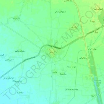
Nome: Mapa topográfico Kunjah, altitude, relevo.
Altitude média: 227 m
Altitude mínima: 221 m
Altitude máxima: 234 m
Faça uma doação
Outros mapas topográficos
Clique em um mapa para visualizar sua topografia, sua altitude e seu relevo.
Lalamusa
Pakistan > Punjab > Gujrat District
Lalamusa is situated on the Grand Trunk Road (National Highway 5). It is geographically located at latitude (32.7 degrees) 32° 42' 0" North of the Equator and longitude (73.96 degrees) 73° 57' 35" East of the Prime Meridian on the Map of the world and lies at an altitude of about 250 meters.
Altitude média: 254 m
Faça uma doação