
Faça uma doação
Mapa topográfico Quisapincha
Clique no mapa para exibir a altitude.
Faça uma doação
Quisapincha
The town has once been the center of Kisapincha resistance against Spanish and Creole intruders. Many of the Kisapincha now live in the high altitude communities that form Quisapincha Alto, part of the parroquia of Quisapincha. The only footpaths connecting Quisapincha Alto with larger cities were constantly watched and could be easily blocked by the defenders. Locals remember that "until 1975 no white man could enter Quisapincha Alto. It was impossible." The parroquia of Quisapincha once had infant mortality of 547 deaths per 1000 births, and the communities of Quisapincha Alto are now growing at 6.3% per annum. During the 1992 uprising the indigenous people of Quisapincha Alto reappropriated the land from the church and gained some Kisapincha representation in local politics. Their rule faces continuing opposition from mestizo townspeople.
Faça uma doação
Sobre este mapa
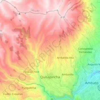
Nome: Mapa topográfico Quisapincha, altitude, relevo.
Local: Quisapincha, Ambato, Tungurahua, Ecuador (-1.26499 -78.78253 -1.13240 -78.65199)
Altitude média: 3.413 m
Altitude mínima: 2.481 m
Altitude máxima: 4.179 m
Faça uma doação
Outros mapas topográficos
Clique em um mapa para visualizar sua topografia, sua altitude e seu relevo.