
Obrigado por apoiar este site ❤️
Faça uma doação
Faça uma doação
Mapa topográfico Dolpa
Clique no mapa para exibir a altitude.
Obrigado por apoiar este site ❤️
Faça uma doação
Faça uma doação
Dolpa
Dolpa is the largest district of Nepal covering 5.36% of the total landmass of the country. It is located at 28°43’N to 29°43’N latitude and 82°23’E to 83°41’E longitude. Elevation ranges from 1,525 to 7,625 m (5,003 to 25,016 ft). The district borders Tibet on the north and northeast, Jumla and Mugu districts on the west, Myagdi, Jajarkot, Western and Eastern Rukum on the south, and Mustang on the east.
Obrigado por apoiar este site ❤️
Faça uma doação
Faça uma doação
Sobre este mapa
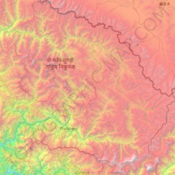
Nome: Mapa topográfico Dolpa, altitude, relevo.
Local: Dolpa, Karnali Province, Nepal (28.72190 82.39256 29.70741 83.67995)
Altitude média: 4.555 m
Altitude mínima: 972 m
Altitude máxima: 8.065 m
Obrigado por apoiar este site ❤️
Faça uma doação
Faça uma doação
Outros mapas topográficos
Clique em um mapa para visualizar sua topografia, sua altitude e seu relevo.