
Mapa topográfico Balabagan
Mapa interativo
Clique no mapa para exibir a altitude.
Sobre este mapa
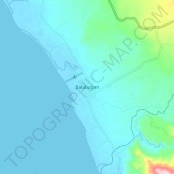
Nome: Mapa topográfico Balabagan, altitude, relevo.
Local: Balabagan, Lanao del Sur, Bangsamoro, Philippines (7.46932 124.08783 7.54932 124.16783)
Altitude média: 47 m
Altitude mínima: 0 m
Altitude máxima: 440 m
Outros mapas topográficos
Clique em um mapa para visualizar sua topografia, sua altitude e seu relevo.
Lake Lanao
The lake has great hydroelectric potential due to its 700 meter elevation, and as such, in 1950, the Philippines National Power Corporation (NAPOCOR) began the construction of a series of hydroelectric plants titled Agus I – Agus VII along the Agus River system, which generates 70% of the electricity used by…
Altitude média: 787 m