

Mapa topográfico Gangtok
Clique no mapa para exibir a altitude.
Gangtok
Gangtok (Nepali: gāntok, pronounced [gantok], Sikkimese: [ɡaŋt̪ʰòk]) is the capital and the most populous city of the Indian state of Sikkim. The seat of eponymous district, Gangtok is in the eastern Himalayan range, at an elevation of 1,650 m (5,410 ft). The city's population of 100,000 consists of the three Sikkimese ethnicities: the Bhutias, Lepchas, Nepalis as well as plainsmen from other states of India. Within the higher peaks of the Himalayas and with a year-round mild temperate climate, Gangtok is at the centre of Sikkim's tourism industry.
Sobre este mapa
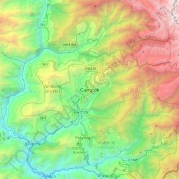
Nome: Mapa topográfico Gangtok, altitude, relevo.
Local: Gangtok, Gangtok subdivision, Gangtok, Sikkim, 737101, India (27.16905 88.45227 27.48905 88.77227)
Altitude média: 1.911 m
Altitude mínima: 283 m
Altitude máxima: 5.193 m
Outros mapas topográficos
Clique em um mapa para visualizar sua topografia, sua altitude e seu relevo.
