
Mapa topográfico Vellore
Mapa interativo
Clique no mapa para exibir a altitude.
Sobre este mapa
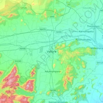
Nome: Mapa topográfico Vellore, altitude, relevo.
Local: Vellore, Vellore District, Tamil Nadu, 632012, India (12.74718 78.97097 13.06718 79.29097)
Altitude média: 283 m
Altitude mínima: 153 m
Altitude máxima: 882 m
Vellore is at 12°55′N 79°08′E / 12.92°N 79.13°E / 12.92; 79.13, 220m above sea level. The city has a tropical savanna climate. It is in the Vellore district of the South Indian state, Tamil Nadu, 135 km (84 mi) west of the state capital Chennai and 30 km (19 mi) kms South of its twin city Chittoor, across the Andhra Pradesh border.Vellore lies in the Eastern Ghats region and Palar river basin. The topography is almost flat with slope from west to east.
Outros mapas topográficos
Clique em um mapa para visualizar sua topografia, sua altitude e seu relevo.
Vallam
India > Tamil Nadu > Vellore
Vallam, Vellore, Vellore District, Tamil Nadu, 632319, India
Altitude média: 203 m