
Obrigado por apoiar este site ❤️
Faça uma doação
Faça uma doação
Mapa topográfico Fürstenfeld
Clique no mapa para exibir a altitude.
Obrigado por apoiar este site ❤️
Faça uma doação
Faça uma doação
Fürstenfeld
Fürstenfeld is located in the lower Feistritz [ceb; de; sh; sv] valley near the Burgenland border. Elevation of the urban area ranges from 255m to approximately 300 m ü. A. The city`s central part sits on a river terrace two dozen meters above the valley floor.
Obrigado por apoiar este site ❤️
Faça uma doação
Faça uma doação
Sobre este mapa
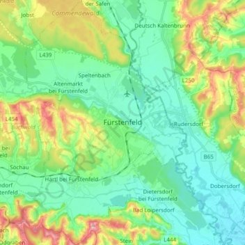
Nome: Mapa topográfico Fürstenfeld, altitude, relevo.
Altitude média: 283 m
Altitude mínima: 232 m
Altitude máxima: 406 m
Obrigado por apoiar este site ❤️
Faça uma doação
Faça uma doação
Outros mapas topográficos
Clique em um mapa para visualizar sua topografia, sua altitude e seu relevo.