
Mapa topográfico Temoaya
Mapa interativo
Clique no mapa para exibir a altitude.
Sobre este mapa
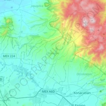
Nome: Mapa topográfico Temoaya, altitude, relevo.
Local: Temoaya, Mexico, 50850, Mexico (19.39625 -99.73111 19.58238 -99.48927)
Altitude média: 2.790 m
Altitude mínima: 2.533 m
Altitude máxima: 3.767 m
The climate is temperate and relatively humid with rains mostly in the summer. Average temperature is 13.4C, ranging between 9 and 35.5C. It is one of the coldest municipalities in the Toluca Valley due to its altitude. Frosts can occur between October and April and morning fog is not uncommon the rest of the year. In the higher elevations there are forest with pine, cedar, oyamel and other trees. In the lower areas there are some broadleaf trees but there are more areas with grass and shrub. Most of the flat areas are cultivated with both field crops and orchards. Very little wildlife remains due to the degradation of most of the ecosystem here. Some small mammals such as squirrels, rabbits and the like remain as well as some bird species. Aquatic life has completely disappeared from the Lerma River area.
Outros mapas topográficos
Clique em um mapa para visualizar sua topografia, sua altitude e seu relevo.
Tejupilco de Hidalgo
Mexico > Mexico > Tejupilco de Hidalgo
Tejupilco de Hidalgo, Tejupilco, Mexico, 51400, Mexico
Altitude média: 1.501 m
Chimalhuacán
Mexico > Mexico > Chimalhuacán
Chimalhuacán, Mexico, 56334, Mexico
Altitude média: 2.304 m
San Pablo de las Salinas
Mexico > Mexico > San Pablo de las Salinas
San Pablo de las Salinas, Tultitlán, Mexico, 549131, Mexico
Altitude média: 2.245 m
San Buenaventura
Mexico > Mexico > San Buenaventura
San Buenaventura, Ixtapaluca, Mexico, 56643, Mexico
Altitude média: 2.285 m
Santa Cruz Atizapán.
Mexico > Mexico > Santa Cruz Atizapán.
Santa Cruz Atizapán., Atizapán, Mexico, 52640, Mexico
Altitude média: 2.602 m
El Oro de Hidalgo
Mexico > Mexico > El Oro de Hidalgo
El Oro de Hidalgo, El Oro, Mexico
Altitude média: 2.809 m