
Mapa topográfico Dubnica nad Váhom
Mapa interativo
Clique no mapa para exibir a altitude.
Sobre este mapa
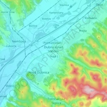
Nome: Mapa topográfico Dubnica nad Váhom, altitude, relevo.
Altitude média: 309 m
Altitude mínima: 215 m
Altitude máxima: 700 m
It is located on the Váh river, in the Ilava Basin, between the White Carpathians and Strážovské vrchy mountains, at an altitude of 242 metres. The town's cadastral area is composed of Dubnica and "city part" Prejta, annexed in 1973.