
Obrigado por apoiar este site ❤️
Faça uma doação
Faça uma doação
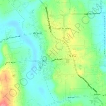
Mapa topográfico Graton
Clique no mapa para exibir a altitude.
Obrigado por apoiar este site ❤️
Faça uma doação
Faça uma doação
Graton
Graton is located at the southeastern end of Green Valley, on the east bank of the seasonally flooding Atascadero Creek. The elevation ranges from approximately 85 feet (26 m) above Mean Sea Level (MSL) at Atascadero Creek to 213 feet (65 m) MSL at Oak Grove School.
Obrigado por apoiar este site ❤️
Faça uma doação
Faça uma doação
Sobre este mapa
Nome: Mapa topográfico Graton, altitude, relevo.
Local: Graton, Sonoma County, California, 95444, United States (38.42220 -122.87740 38.45507 -122.85053)
Altitude média: 50 m
Altitude mínima: 20 m
Altitude máxima: 110 m
Obrigado por apoiar este site ❤️
Faça uma doação
Faça uma doação