
Mapa topográfico Hemingbrough
Mapa interativo
Clique no mapa para exibir a altitude.
Sobre este mapa
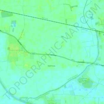
Nome: Mapa topográfico Hemingbrough, altitude, relevo.
Altitude média: 5 m
Altitude mínima: -1 m
Altitude máxima: 11 m
Outros mapas topográficos
Clique em um mapa para visualizar sua topografia, sua altitude e seu relevo.
Saxton
United Kingdom > England > Selby > Saxton
Saxton, Selby, North Yorkshire, Yorkshire and the Humber, England, LS24 9PZ, United Kingdom
Altitude média: 32 m
Brotherton
United Kingdom > England > Selby > Brotherton
Brotherton, Selby, North Yorkshire, Yorkshire and the Humber, England, United Kingdom
Altitude média: 16 m
Carlton
United Kingdom > England > Selby > Carlton
Carlton, Selby, North Yorkshire, Yorkshire and the Humber, England, DN14 9PB, United Kingdom
Altitude média: 5 m
Carlton
United Kingdom > England > Selby
Carlton, Selby, North Yorkshire, Yorkshire and the Humber, England, United Kingdom
Altitude média: 6 m
Beal
United Kingdom > England > Selby
Beal, Selby, North Yorkshire, Yorkshire and the Humber, England, United Kingdom
Altitude média: 10 m
Brayton
United Kingdom > England > Selby
Brayton, Selby, North Yorkshire, Yorkshire and the Humber, England, United Kingdom
Altitude média: 8 m
Byram cum Sutton
United Kingdom > England > Selby
Byram cum Sutton, Selby, North Yorkshire, Yorkshire and the Humber, England, United Kingdom
Altitude média: 13 m
Camblesforth
United Kingdom > England > Selby
Camblesforth, Selby, North Yorkshire, Yorkshire and the Humber, England, United Kingdom
Altitude média: 6 m
Kellington
United Kingdom > England > Selby
Kellington, Selby, North Yorkshire, Yorkshire and the Humber, England, United Kingdom
Altitude média: 11 m