
Mapa topográfico San Antonio
Mapa interativo
Clique no mapa para exibir a altitude.
Sobre este mapa
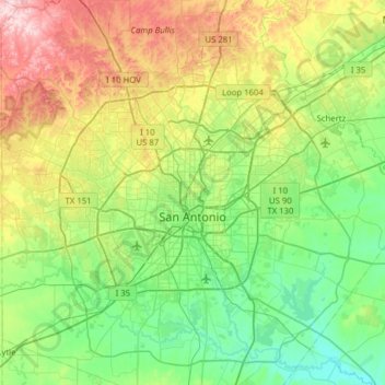
Nome: Mapa topográfico San Antonio, altitude, relevo.
Local: San Antonio, Bexar County, Texas, United States (29.18626 -98.81319 29.73096 -98.22300)
Altitude média: 247 m
Altitude mínima: 117 m
Altitude máxima: 575 m
San Antonio is approximately 75 miles (121 km) to the southwest of its neighboring city, Austin, the state capital, about 190 miles (310 km) west of Houston, and about 250 miles (400 km) south of the Dallas–Fort Worth area. The city has a total area of 465.4 square miles (1,205.4 km2); 460.93 square miles (1,193.8 km2) of San Antonio's total area is land and 4.5 square miles (11.7 km2) of it is water. The city's gently rolling terrain is dotted with oak trees, forested land, mesquite, and cacti. The Texas Hill Country reaches into the far northern portions of the city. San Antonio sits on the Balcones Escarpment. Its altitude is approximately 662 feet (202 m) above sea level.
Outros mapas topográficos
Clique em um mapa para visualizar sua topografia, sua altitude e seu relevo.
Converse
United States > Texas > Bexar County
Converse, Bexar County, Texas, 78109, United States
Altitude média: 223 m
Converse
United States > Texas > Bexar County > Converse > Converse
Converse, Bexar County, Texas, 78109, United States
Altitude média: 230 m
Castle Hills
United States > Texas > Bexar County > Castle Hills
Castle Hills, Bexar County, Texas, 78213, United States
Altitude média: 257 m