
Mapa topográfico Dewey Lake
Mapa interativo
Clique no mapa para exibir a altitude.
Sobre este mapa
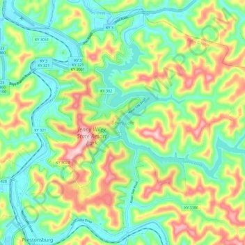
Nome: Mapa topográfico Dewey Lake, altitude, relevo.
Altitude média: 273 m
Altitude mínima: 181 m
Altitude máxima: 435 m
Outros mapas topográficos
Clique em um mapa para visualizar sua topografia, sua altitude e seu relevo.
Prestonsburg
United States > Kentucky > Floyd County > Prestonsburg > Prestonsburg
Prestonsburg, Floyd County, Kentucky, 41653, United States
Altitude média: 274 m