
Faça uma doação
Mapa topográfico Azena
Clique no mapa para exibir a altitude.
Faça uma doação
Sobre este mapa
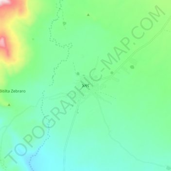
Nome: Mapa topográfico Azena, altitude, relevo.
Local: Azena, Awi Agew, Amhara Region, Ethiopia (10.72321 36.77466 10.80321 36.85466)
Altitude média: 2.086 m
Altitude mínima: 1.929 m
Altitude máxima: 2.587 m
Faça uma doação
Outros mapas topográficos
Clique em um mapa para visualizar sua topografia, sua altitude e seu relevo.
Simien Mountains National Park
The vegetation is mixed with African alpine forests, wilderness forests and alpine vegetation. High altitude areas include montane savannah and tree heath (Erica arborea), giant lobelia (Lobelia rhynchopetalum), yellow primrose (Primula verticillata), everlastings (Helichrysum spp.), a lady's mantle…
Altitude média: 2.337 m
Simien Mountains National Park
The vegetation is mixed with African alpine forests, wilderness forests and alpine vegetation. High altitude areas include montane savannah and tree heath (Erica arborea), giant lobelia (Lobelia rhynchopetalum), yellow primrose (Primula verticillata), everlastings (Helichrysum spp.), A lady's mantle…
Altitude média: 2.337 m
Faça uma doação
Bahir Dar Special Zone
Bahir Dar is located at the exit of the Abbay from Lake Tana at an altitude of 1,820 metres (5,970 ft) above sea level. The city is located approximately 578 km north-northwest of Addis Ababa. The Lake Tana region is a UNESCO Biosphere Reserve since 2015.
Altitude média: 1.794 m
Faça uma doação
Awi Agew
Topographically speaking, Agaw Awi is relatively flat and fertile, whose elevations vary from 1,800 to 3,100 m above sea level, with an average altitude of about 2,300 m. The Zone is crossed by about nine permanent rivers which drain into the Abay (or Blue Nile); other water features include two crater lakes,…
Altitude média: 1.640 m
Bahir Dar Special Zone
Bahir Dar is located at the exit of the Abbay from Lake Tana at an altitude of 1,820 metres (5,970 ft) above sea level. The city is located approximately 578 km north-northwest of Addis Ababa. The Lake Tana region is a UNESCO Biosphere Reserve since 2015.
Altitude média: 1.794 m
Faça uma doação
Awi Agew
Topographically speaking, Agaw Awi is relatively flat and fertile, whose elevations vary from 1,800 to 3,100 m above sea level, with an average altitude of about 2,300 m. The Zone is crossed by about nine permanent rivers which drain into the Abay (or Blue Nile); other water features include two crater lakes,…
Altitude média: 1.640 m
Faça uma doação