
Obrigado por apoiar este site ❤️
Faça uma doação
Faça uma doação
Mapa topográfico Montalban
Clique no mapa para exibir a altitude.
Obrigado por apoiar este site ❤️
Faça uma doação
Faça uma doação
Montalban
Rodriguez is generally very rough in topography, with 83% of its total land area composed of upland areas, hills and mountain ranges. The remaining 17% low-lying terrain and rolling lands are found at the south-western portion of the municipality, along with the northern portions of the Municipality of San Mateo.
Obrigado por apoiar este site ❤️
Faça uma doação
Faça uma doação
Sobre este mapa
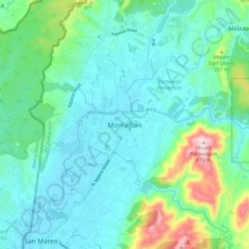
Nome: Mapa topográfico Montalban, altitude, relevo.
Local: Montalban, Rizal, Calabarzon, 1860, Philippines (14.69247 121.10527 14.77247 121.18527)
Altitude média: 99 m
Altitude mínima: 8 m
Altitude máxima: 459 m
Obrigado por apoiar este site ❤️
Faça uma doação
Faça uma doação