
Obrigado por apoiar este site ❤️
Faça uma doação
Faça uma doação
Mapa topográfico Highlands
Clique no mapa para exibir a altitude.
Obrigado por apoiar este site ❤️
Faça uma doação
Faça uma doação
Highlands
Highlands was founded in 1875 after its two founders, Samuel Truman Kelsey and Clinton Carter Hutchinson, drew lines from Chicago to Savannah and from New Orleans to New York City. They felt that the place where these lines met would eventually become a great trading center and commercial crossroads. Highlands was named for its lofty elevation.
Obrigado por apoiar este site ❤️
Faça uma doação
Faça uma doação
Sobre este mapa
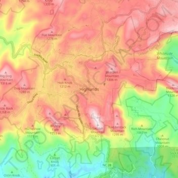
Nome: Mapa topográfico Highlands, altitude, relevo.
Altitude média: 1.090 m
Altitude mínima: 767 m
Altitude máxima: 1.360 m
Obrigado por apoiar este site ❤️
Faça uma doação
Faça uma doação