
Mapa topográfico Alton
Mapa interativo
Clique no mapa para exibir a altitude.
Sobre este mapa
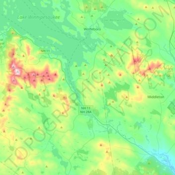
Nome: Mapa topográfico Alton, altitude, relevo.
Local: Alton, Belknap County, New Hampshire, United States (43.35532 -71.34420 43.62922 -71.15894)
Altitude média: 235 m
Altitude mínima: 71 m
Altitude máxima: 717 m
According to the United States Census Bureau, the town has a total area of 82.2 square miles (212.9 km2), of which 62.9 square miles (162.9 km2) is land and 19.3 square miles (50.0 km2) is water, comprising 23.49% of the town. Alton is located at the southern end of Lake Winnipesaukee, around the 4-mile-long (6.4 km) inlet known as Alton Bay. The village of Alton Bay is located at the southern tip of the bay, while the main village of Alton is located 1 mile (1.6 km) farther south. The town is drained by the Merrymeeting River, the main inlet to Alton Bay. Mount Major, in Mount Major State Forest, has an elevation of 1,780 feet (540 m) above sea level. Popular with hikers, the summit offers unsurpassed views of Lake Winnipesaukee. The highest point in Alton is the north peak of Straightback Mountain, at 1,910 ft (580 m), just west of Mount Major. Both mountains are part of the Belknap Mountains range. Alton lies almost fully within the Merrimack River watershed, though a tiny corner is in the Piscataqua River (coastal) watershed.
Outros mapas topográficos
Clique em um mapa para visualizar sua topografia, sua altitude e seu relevo.
Winnisquam
United States > New Hampshire > Belknap County > Tilton
Winnisquam, Tilton, Belknap County, New Hampshire, 03289, United States
Altitude média: 175 m
Glendale
United States > New Hampshire > Belknap County > Gilford
Glendale, Gilford, Belknap County, New Hampshire, 03249, United States
Altitude média: 181 m
Weirs Beach
United States > New Hampshire > Belknap County > Laconia > Interlaken Park
Weirs Beach, Interlaken Park, Laconia, Belknap County, New Hampshire, 03247, United States
Altitude média: 179 m
Lakeport
United States > New Hampshire > Belknap County > Laconia
Lakeport, Laconia, Belknap County, New Hampshire, 03246, United States
Altitude média: 180 m
Squam Lake
United States > New Hampshire > Belknap County > Center Harbor
Squam Lake, Center Harbor, Belknap County, New Hampshire, United States
Altitude média: 220 m
Meredith
United States > New Hampshire > Belknap County
Meredith, Belknap County, New Hampshire, 03253, United States
Altitude média: 215 m
Hopkinson Hill
United States > New Hampshire > Belknap County > Sanbornton
Hopkinson Hill, Sanbornton, Belknap County, New Hampshire, 03269, United States
Altitude média: 292 m
Lake Manning
United States > New Hampshire > Belknap County > Gilmanton
Lake Manning, Gilmanton, Belknap County, New Hampshire, United States
Altitude média: 248 m
Sunset Lake
United States > New Hampshire > Belknap County > Alton
Sunset Lake, Alton, Belknap County, New Hampshire, United States
Altitude média: 268 m
Gilford
United States > New Hampshire > Belknap County
Gilford, Belknap County, New Hampshire, 03249, United States
Altitude média: 231 m
Laconia
United States > New Hampshire > Belknap County
Laconia, Belknap County, New Hampshire, United States
Altitude média: 203 m
Sanbornton
United States > New Hampshire > Belknap County
Sanbornton, Belknap County, New Hampshire, 03269, United States
Altitude média: 228 m
Governors Island
United States > New Hampshire > Belknap County > Gilford > Dockham Shore
Governors Island, Dockham Shore, Gilford, Belknap County, New Hampshire, United States
Altitude média: 162 m
Lochmere
United States > New Hampshire > Belknap County > Belmont
Lochmere, Belmont, Belknap County, New Hampshire, 03252, United States
Altitude média: 173 m
Adams Pond;Adams Pond Dam
United States > New Hampshire > Belknap County > Alton
Adams Pond;Adams Pond Dam, Alton, Belknap County, New Hampshire, 03809, United States
Altitude média: 252 m
Gilmanton Ironworks
United States > New Hampshire > Belknap County > Gilmanton
Gilmanton Ironworks, Gilmanton, Belknap County, New Hampshire, 03837, United States
Altitude média: 224 m
Gilmanton
United States > New Hampshire > Belknap County
Gilmanton, Belknap County, New Hampshire, United States
Altitude média: 257 m
Welch Island
United States > New Hampshire > Belknap County > Gilford
Welch Island, Gilford, Belknap County, New Hampshire, United States
Altitude média: 153 m
Gunstock Mountain
United States > New Hampshire > Belknap County > Gilford
Gunstock Mountain, Gilford, Belknap County, New Hampshire, 03249, United States
Altitude média: 456 m
Center Harbor
United States > New Hampshire > Belknap County
Center Harbor, Belknap County, New Hampshire, United States
Altitude média: 214 m
Laconia
United States > New Hampshire > Belknap County > Laconia
Laconia, Belknap County, New Hampshire, 03246, United States
Altitude média: 227 m
Yale Estates
United States > New Hampshire > Belknap County > Gilford > Yale Estates
Yale Estates, Gilford, Belknap County, New Hampshire, United States
Altitude média: 390 m
Winona
United States > New Hampshire > Belknap County > New Hampton > Winona
Winona, New Hampton, Belknap County, New Hampshire, United States
Altitude média: 232 m
Tilton
United States > New Hampshire > Belknap County
Tilton, Belknap County, New Hampshire, United States
Altitude média: 196 m
Center Barnstead
United States > New Hampshire > Belknap County > Barnstead
Center Barnstead, Barnstead, Belknap County, New Hampshire, 03218, United States
Altitude média: 183 m
New Hampton
United States > New Hampshire > Belknap County
New Hampton, Belknap County, New Hampshire, 03256, United States
Altitude média: 264 m
Belmont
United States > New Hampshire > Belknap County
Belmont, Belknap County, New Hampshire, United States
Altitude média: 232 m
Belknap Mountain
United States > New Hampshire > Belknap County > Gilford
Belknap Mountain, Gilford, Belknap County, New Hampshire, 03249, United States
Altitude média: 498 m
Alton Bay
United States > New Hampshire > Belknap County > Alton
Alton Bay, Alton, Belknap County, New Hampshire, 03809, United States
Altitude média: 226 m