
Mapa topográfico Schling
Mapa interativo
Clique no mapa para exibir a altitude.
Sobre este mapa
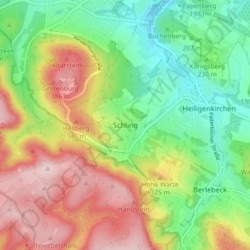
Nome: Mapa topográfico Schling, altitude, relevo.
Altitude média: 255 m
Altitude mínima: 143 m
Altitude máxima: 401 m
Outros mapas topográficos
Clique em um mapa para visualizar sua topografia, sua altitude e seu relevo.
Klüt
Deutschland > Nordrhein-Westfalen > Kreis Lippe > Detmold
Klüt, Detmold, Kreis Lippe, Nordrhein-Westfalen, Deutschland
Altitude média: 187 m
Berlebeck
Deutschland > Nordrhein-Westfalen > Kreis Lippe > Detmold
Berlebeck, Detmold, Kreis Lippe, Nordrhein-Westfalen, Deutschland
Altitude média: 296 m