
Mapa topográfico Shirley
Mapa interativo
Clique no mapa para exibir a altitude.
Sobre este mapa
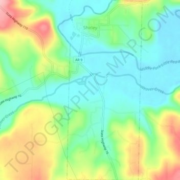
Nome: Mapa topográfico Shirley, altitude, relevo.
Local: Shirley, Van Buren County, Arkansas, 72153, United States (35.62634 -92.32541 35.66295 -92.30434)
Altitude média: 205 m
Altitude mínima: 152 m
Altitude máxima: 304 m
Outros mapas topográficos
Clique em um mapa para visualizar sua topografia, sua altitude e seu relevo.
Fairfield Bay
United States > Arkansas > Van Buren County
Fairfield Bay, Van Buren County, Arkansas, 72088, United States
Altitude média: 230 m
Hatley Mountain
United States > Arkansas > Van Buren County
Hatley Mountain, Van Buren County, Arkansas, United States
Altitude média: 445 m
Shirley
United States > Arkansas > Van Buren County > Shirley > Shirley
Shirley, Van Buren County, Arkansas, 72153, United States
Altitude média: 213 m
Clinton
United States > Arkansas > Van Buren County
Clinton, Van Buren County, Arkansas, 72031, United States
Altitude média: 230 m
Botkinburg
United States > Arkansas > Van Buren County > Botkinburg
Botkinburg, Van Buren County, Arkansas, 72629, United States
Altitude média: 379 m
Bee Branch
United States > Arkansas > Van Buren County
Bee Branch, Van Buren County, Arkansas, 72013, United States
Altitude média: 251 m