
Mapa topográfico José Falcón
Mapa interativo
Clique no mapa para exibir a altitude.
José Falcón
Located in the Western region of Paraguay, in the area of Paraguayan Chaco. Its physical appearance is part of the characteristics of the Chaco soil: lowland with abundant vegetation of palm trees. It is a coastal city located at the junction between the Pilcomayo and Paraguay rivers. This district is located in a lowland area with clay soil. With no meaningful elevations. The geography in general at this part of the department is characterized by being swampy, with palm trees and grasses. It is a region that is highly prone to flooding in the rainy seasons of the year.
Sobre este mapa
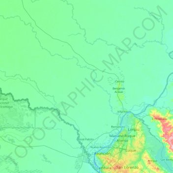
Nome: Mapa topográfico José Falcón, altitude, relevo.
Local: José Falcón, Presidente Hayes, Región Occidental, Paraguay (-25.27014 -58.50207 -24.68955 -57.64361)
Altitude média: 74 m
Altitude mínima: 49 m
Altitude máxima: 272 m
Outros mapas topográficos
Clique em um mapa para visualizar sua topografia, sua altitude e seu relevo.