
Obrigado por apoiar este site ❤️
Faça uma doação
Faça uma doação
Mapa topográfico Ebbetts Pass
Clique no mapa para exibir a altitude.
Obrigado por apoiar este site ❤️
Faça uma doação
Faça uma doação
Sobre este mapa
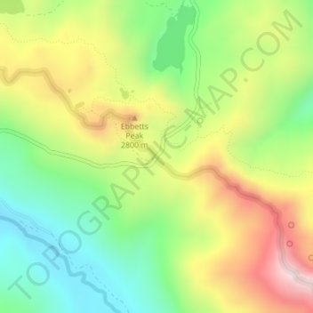
Nome: Mapa topográfico Ebbetts Pass, altitude, relevo.
Altitude média: 2.632 m
Altitude mínima: 2.383 m
Altitude máxima: 2.962 m
Obrigado por apoiar este site ❤️
Faça uma doação
Faça uma doação
Outros mapas topográficos
Clique em um mapa para visualizar sua topografia, sua altitude e seu relevo.
Bear Valley
United States > California > Alpine County
Bear Valley's central Sierra location and elevation gives it a warm-summer Mediterranean climate that is nearly a subarctic climate. Precipitation is seen for a lot of the year except for the middle of the summer, which can experience rare, but not unseen, thunderstorms. Late fall to early spring brings in…
Altitude média: 2.280 m
Obrigado por apoiar este site ❤️
Faça uma doação
Faça uma doação